
| Home |
| Example: rivers |
| Versions |
| References |
| Contacts |
| FAQ |
| Download |

DASSFLOW
Examples of applications
The present page can give you a good idea of DassFlow's features (below: use of former versions V1.1 and V1.3), even if this page is not up-to-date.Few other applications have been developped or are under progress by colleagues:
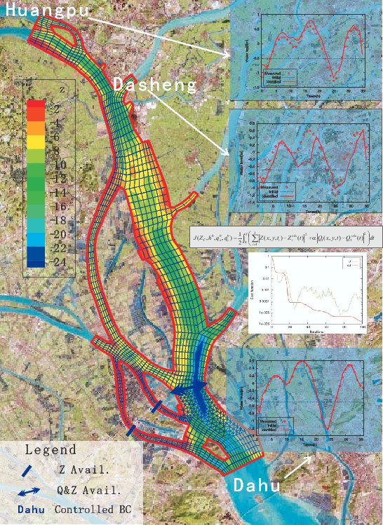
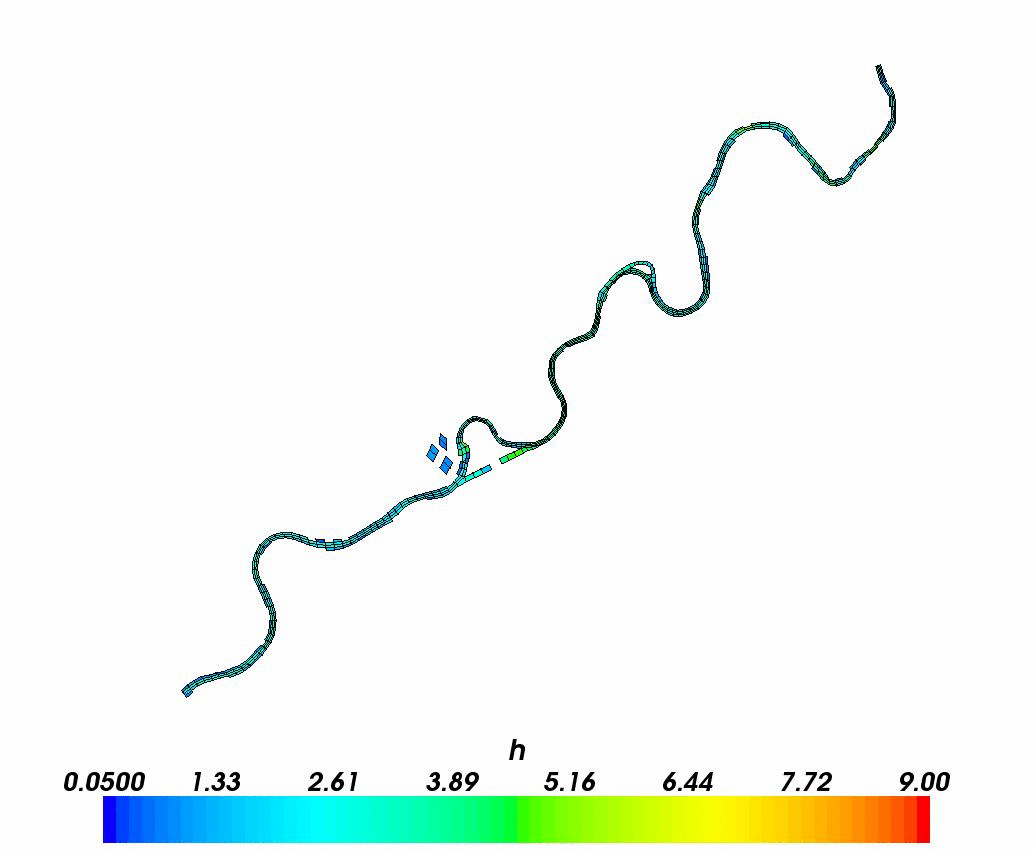
Identification of inflow discharges. Pearl River, China.
Collaboration X. Lai (Niglas, Nanjin, China), J. Monnier.- Identification of inflow discharge (at 3 boundaries)
- Observations :
- water elevation at 3 gauging stations
- discharge at 1 gauging station
Reference :
- Variational data assimilation for 2D fluvial hydraulics simulation.
M. Honnorat, X. Lai, J. Monnier, FX Le Dimet.
Invited talk at CMWR XVI-Computational Methods for Water Ressources. Copenhagen, june 2006.
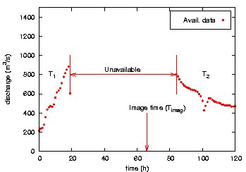
Assimilation of one satellite image. Flood plain, Moselle River, France.
Collaboration: R. Hostache (PhD Cemagref 03-06), X. Lai (Niglas, China), J. Monnier, C. Puech (D.R. Cemagref Montpellier / Engref).- Observations :
- Partial discharge measurements from the EDF station
- One satellite image : partial elevation values
 |
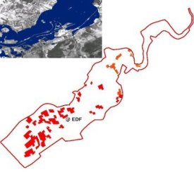 |
| Observations from the EDF station
: discharge values |
Reliable elevation values
extracted from the satellite image Work done by R. Hostache and C. Puech |
- Sensitivities and identification of Manning coefficients
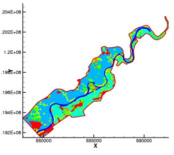
Manning coefficients: 10 land-uses
An video of a direct simulation on the Moselle River is available.
References :
- "Assimilation of spatial distributed water levels into a shallow-water flood model. Part II: using a remote sensing image of Mosel river". R. Hostache, X. Lai, J. Monnier, C. Puech. J. Hydrology Vol. 390, Issues 3-4, pp 257-268 (2010).
- "Assimilation of spatial distributed water levels into a shallow-water flood model. Part I: mathematical method and test case". X. Lai, J. Monnier. J. Hydrology. Vol. 377, Issue 1-2, pp. 1-11 (2009).
Estimation de niveaux d'eau en plaine inondée à partir d'images satellites RADAR et de données topographiques fines
Hostache R. & Puech C. 2007, revue Télédétection.
Lagrangian data
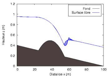
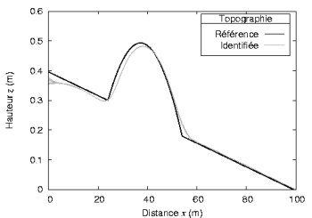
Identification of the topography. Toy test case.
Collaboration M. Honnorat (PhD'07, Grenoble), J. Monnier, FX Le Dimet (U. Grenoble).Configuration :
- Flow over a bump in a canal
- First guess : constant topography slope
Observations :
- Particle trajectories at surface
- Elevation at x=15m and x=70m
 |
 |
|
Topography and reference
flow
|
Reference and identified
topography
|
References :
- "Lagrangian data assimilation for river hydraulics simulations". M. Honnorat, J. Monnier, FX Le Dimet (U. Grenoble). Comput. Visu. Sc. (CVS). Vol. 12, Issue 5, pp. 235 (2009).
- "Lagrangian data assimilation for river hydraulics simulation". M. Honnorat's Phd thesis (in french), Grenoble Inst. Tech., 2007.
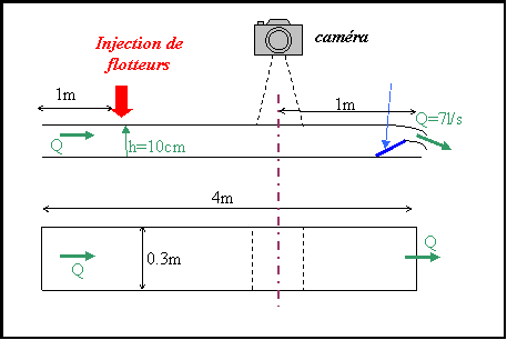
Identification of the topography in a canal using a video camera.
Collaboration: M. Honnorat (PhD'07, Grenoble), J. Monnier, N. Rivière (Insa Lyon), E. Huot (Inria), FX Le Dimet (U. Grenoble).- Video from an experiment conducted at the LMFA laboratory (N.
Rivière, LMFA Lyon) :
- flow over a plank in a canal
- floating particles (confetti) are introduced
- Particle trajectories are extracted from the video (E. Huot, INRIA Clime Project)
- Identification of an "equivalent" topography (i.e. real topography + recirculation); identification of an "equivalent" Manning coefficient.
 |
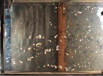 |
| Experiment configuration | Image shot from the video: tracers at surface |
References :
- "Identification of equivalent topography in an open channel flow using Lagrangian data assimilation." M. Honnorat, J. Monnier, N. Riviere, E. Huot, FX Le Dimet. Comput. Visu. Sc. (CVS). Vol. 13, Issue 3 (2010), pp. 111.
- "Lagrangian data assimilation for river hydraulics simulation". M. Honnorat's Phd thesis (in french), Grenoble Inst. Tech., 2007.
Joint Assimilation Coupling algorithm: 2D zoom model over 1D global model
Collaboration: I. Gejadze (U. Strathclyde), J. Marin (engineer), J. Monnier, J.-B. Faure (Cemagref Lyon).
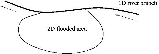 1D main channel coupled with 2D plain area |
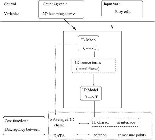 JAC Algorithm performs calibration (data assimilation) and coupling simultaneously. |
References:
-
"On a 2D zoom for 1D shallow-water model: coupling and data assimilation".
I. Gejadze, J. Monnier.
Comp. Meth. Appl. Mech. Eng. (CMAME) Vol. 196, issues 45-48, pp 4628-4643 (2007). - "Superposition of local zoom model and simultaneous calibration for 1D-2D shallow-water flows"..
J. Marin, J. Monnier.
Math. Comput. Simul. 80 (2009), pp. 547-560. -
"Coupling superposed 1D and 2D shallow-water models: source terms and finite volume schemes"..
E. Fernandez-Nieto, J. Marin, J. Monnier.
Comput. Fluid. Vol.39, Issue 6, pp 1070-1082. (2010).